AND THE 2D BN, 310TH INFANTRY (78TH INF. DIV.),
IN THE ATTACK ON KESTERNICH, GERMANY,
14 - 15 DECEMBER 1944
By Lieutenant Colonel Lawrence H. Kenman, Infantry

INTRODUCTION
This monograph covers the operations of the 2d Battalion, 309th Infantry, and the 3d Battalion, 310th Infantry, 78th Infantry Division, in the attack on the town of Kesternich, Germany, 14-15 December 1944, during the offensive to seize the Roer River dams.
For the purpose of orienting the reader, it is essential to present the situation on the Western Front, and the events leading up to this action.
By the fall of 1944, the German army had been driven from France, Luxembourg, and Belgium.
Seven Allied armies faced the Germans on the Western Front. The First United States Army had taken the German city of Aachen on 21 October, and in early December was generally disposed along the Siegfried Line defenses. The Ninth United States Army to the north had reached the Roer River. To the south the Third United States Army had reached the Saar and Moselle Rivers and had breached a portion of the Siegfried Line at Saarlautern. 1
The Siegfried Line, built on natural barriers immediately east of the German border, consisted of dragon's teeth antitank obstacles, pillboxes, dugouts, trenches, and wire entanglements, constructed in series. In areas where nature provided the least for defense, artificial obstacles were the strongest. Dragon's teeth were more numerous where river barriers were lacking. Pillboxes were made of heavy reinforced concrete and steel, constructed in clusters to provide mutual support by interlocking bands of fire* Some were built into the sides of hills and were well camouflaged while others were in sub-basements of what appeared to be nothing other than German family residences. They were equipped with telephone intercommunication systems and, in the larger ones, sleeping quarters. 2
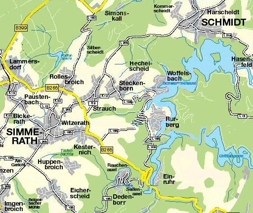
To provide depth, many villages well within the German border, containing houses of heavy concrete construction, were well fortified as strongpoints, (See Map A) This was particularly true of the villages of Schmidt, Steckenborn, Eichersheid, Gemund, Schleiden, and Losheim, southeast of Aachen, and in the path of the First United States Army. 3
THE GENERAL SITUATION
The Boer River, a small river approximately ten thousand yards east of the First United States Army front, was not in itself a major barrier, (See Map A} However, seriously restraining the progress of the First and Ninth United States Armies were, the dams on the Boer and Urft Rivers in the vicinity of Schmidt, approximately ten miles southeast of Aachen in the V Corps zone. Lakes created behind these dams held billions of gallons of water which, if unleashed by only a two-thirds destruction of the largest of the dams, the Schwammenauel, would cause the river to rise an estimated twenty-five to thirty feet in six hours and to widen to one and one-half miles at Duren to the north for a period of two days, as well as cause an increase in velocity from five to sixteen feet per second. 4
Concerning the importance of these dams, the Chief of Staff, United States Army, in his Biennial Report for the period 1 July 1943 to 30 June 1945 states, "He (the enemy) is assisted in the area, however, by the flooded condition of the Roer River and the capability he has of producing a sudden rush of water by blowing the dams near Schmidt. Bradley has about come to the conclusion that we must take that area by a very difficult attack from west and southwest." 5
Destruction of these dams by aerial bombing would immediately cut off those German forces west of the Roer River and would insure eventual Allied crossings without threat of flood disasters during the operations. However, destruction by bombing had been tried earlier. Heavy bombs failed to effect destruction of the dams due to their combined earth and concrete construction. 6
American forces had previously attempted to capture the dams by attacks, via Schmidt, from the northwest. As late as 2 November the 23th Infantry Division attacked with the mission of securing the Vossenack - Schmidt - Strauch area for the purpose of gaining control of the dams. Its 112th Infantry entered the village of Schmidt on 3 November but withdrew under an enemy counterattack, by the German 89th Infantry Division and 116th Panzer Division, suffering heavy casualties and equipment losses. 7
The enemy was determined to deny penetration of the approaches to the two key dams, the Schwammenauel and the Urfttallsperre. Fully aware of our intentions in this area he had increased his capability of defending west of the Roer with divisions of the Sixth SS Panzer Army in addition to the 2d and 116th Panzer Divisions which were available for local counterattack. 8
V Corps with its recent addition of the 2d and 78th Infantry Divisions, was ordered by First Army to attack not earlier than 13 December with the mission of seizing and securing the Schwammenauel and Urfttalsperre Dams. 9
On 7 December, V Corps issued its order for the attack. The 2d Infantry Division, in conjunction with the 99th Infantry Division on the Corps right, was to advance east to the Urft River and seise the Urfttalsperre Dam. The 78th Infantry Division (less 311th RCT) on the left of the 2d Infantry Division was to pass through the line held by the 102d Cavalry Group in the Lanmersdorf area and attack in three phases. Phase one included the seizure of the towns of Rollesbroich, Bickerath, Simmerath, Kesternich, and the high ground east thereof. Phase two provided for a turn to the south to capture the towns of Konzen, Imgenbroich, and Eichersheid, in order to secure the right flank. Phase three included an attack to the northeast to capture the towns of Strauch, Steckenborn, and Schmidt; then a turn to the southeast to seize the final objective, the Schwammenauel Dam. The 8th Infantry Division (plus 311th RCT) on the Corps left was to exert pressure along the Kall River line. 10