
The rectangular coordinate grid system used on old military maps, covering most of Western Europe, is called the “Nord de Guerre Zone Grid”.
The grid consists of two sets of equally spaced parallel lines mutually perpendicular to one another, forming a pattern of squares.
It was during World War I that the French adopted the rectangular Nord de Guerre grid based on a conical projection, the Lambert Conformal Conic. After World War I, the French extended the system with new Lambert Conformal grids named “Lambert Zones I, II, and III”, to cover the rest of the French territory.
In 1919, Great Britain adopted the "British System", based on a Cassini Projection and on the use of a reference grid. This system was superseded in 1927 by the "Modified British System", more adapted to the coverage of large areas.
In the Modified British System, each projected area is divided into squares of 500 kilometers side, each of which is designated by a letter. Each of these squares is subdivided into 25 squares of 100 kilometers side which are also lettered from "A" to "Z" omitting the letter "I".
These squares of 100 kilometers side, which play a fundamental role in the determination of the coordinates, and are thus often represented on the maps of the time, are referred to in a complete way by the combination of two letters, for example, 'vK', indicating here the 100 km square K included in the 500 km square v.
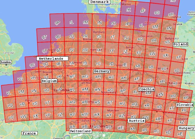
Diagram of the grid used for the "Nord de Guerre Zone"
in the "Modified British System"
The Huertgen Forest is situated in squares VK and WF.
Below is the grid data of the French Nord de Guerre grid:
- Projection: Lambert (Modified)
Conical Orthomorphic - Spheriod: Du Plessis (Reconstituded)
- Origin: 55 Grades North, 6 Grades East of Paris
- False Co-ordinates of origin: 600,000 metres East, 300,000 metres North
- Longitude of Paris is 2°20’14” East of Greenwich
Note about Grades:
Sometimes confusion can occur with the existing term grad(e) in some northern European countries, meaning a standard degree or 1/360 of a turn. The French grade or gradian is a unit of measurement of an angle, defined as one hundredth of the right angle; in other words, there are 100 grades in 90 degrees. It is equivalent to 1/400 of a turn, 9/10 of a degree, or π/200 of a radian. Measuring angles in gradians is said to employ the Centesimal System of angular measurement, initiated as part of metrication and decimalization efforts.
The conversion of 55 Grades and 6 Grades East goes as follows:
55 grades x (360/400) = 49.5 decimal degrees, or 49°30’00” North, and
6 Grades x 0.9 = 5.4 decimal degrees, or 5°24’00” East of Paris.
As mentioned before the longitude of Paris is 2°20’14” East of Greenwich
Thus the latitude of the point of origin = 49°30’00” North, and
the longitude of the point of origin = 5°24’00” + 2°20’14” = 7°44’14” East.
If you fill in 49°30’00”N 7°44’14”E in Google Maps, the point of origin is situated just north of the village of Otterbach and West of the village of Otterberg.
According to the Nord de Guerre grid data, this point of origin receives a false Easting of 600,000 meters and a false Northing of 300,000 meters.
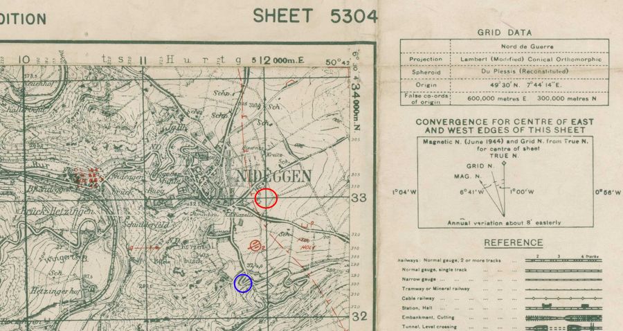
A section of a 1944 map, scale 1:25,000, with the NDG grid drawn in black.
At the top of the map, you'll notice the tick marks 10, 11, 512,000 m.E., and on the right, you'll notice tick marks 32, 33, 434,000 m.N. The intersection of the grid lines marked with 512,000 m.E. and 33 (433,000 m.N) intersect at the eastern edge of the town of Nideggen. Also note that the point of origin, in the table of the grid data, has been converted to the Greenwich meridian.
The American army in World War II used a six-digit grid reference, that depended on the (false) eastings and northings.
An explanation of how to determine the grid coordinates of a point on a military map can be found here (the link will open an external website).
In the above example the map reference of the intersection, marked by the red circle, would be referred to as 120330. The hundred thousandth digits are omitted. The town of Nideggen is situated in quadrant WF (see above diagram). If you browse to the Echodelta Coordinator Webpage and change British Cassini Grid to Nord de Guerre Grid and enter map reference WF120330 in the input box, you'll get the latitude and longitude of this map reference. In the six-digit grid reference, the precision is to the nearest 100 meters.
As an example, the hairpin turn in the above blue circle would be referenced as follows:
By use of a protractor, the grid square gets divided by 10 tick marks. On a scale of 1:25,000, these tick marks have a separation of 100 meters. In our example, the hairpin turn is about 800 meters to the East of the 11th tick mark (top scale), so the first 3 digits of the reference become 11 8 and the next 3 digits would become 32 3 (about 300 meters North of 32-mark, right scale). Thus, the map reference of the hairpin turn would be 118323. Again if you browse to the Echodelta Coordinator Webpage and change British Cassini Grid to Nord de Guerre Grid and enter map reference WF118323 in the input box, you'll get the latitude and longitude (Lon: 50° 41' 01''N Lat: 6° 29' 18''E) of this map reference. By doing so you'll notice that the conversion is not highly accurate, that's why it's better to use a topographic map of that time.
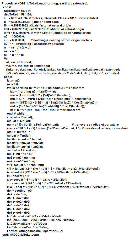
As a hobby programmer, I wanted to write a PC program that was able to convert the 6 digits map reference into latitude and longitude. It took me a very long time to achieve this. For readers of this page who are interested in this stuff, I include the source code, in Pascal language, below:
I hope this webpage was somewhat useful to you.
~ ~ ~ SCORPIO ~ ~ ~