Places to visit in the Huertgen Forest?
-
Cahow's and Dempfle memorials, and destroyed pillboxes in the area near the Raffelsbrand Junction.
Park your car here: Link to Google Maps cross the road and follow hiking path #8.
-
The Cemetery of Honor for German Soldiers (Ehrenfriedhof) of Vossenack: Link to Google Maps
Photos of the cemetery can be found here on my website.
-
The hamlet of Simonskall: Link to Google Maps and the remains of pillbox #59 at this location: Link to Google Maps
Restaurant Tallschenke is located here: Link to Google Maps -
The Church of Vossenack: Link to Google Maps
Read the personal account of Henri Kalinowsky here.
Close to the church, the memorial cross made of shrapnel: Link to Google Maps
-
A must see in Vossenack is the Museum - Huertgenwald 1944 and in peacetime.
Check this website http://www.museum-huertgenwald.de for opening hours.
-
Cemetery of Honor for German Soldiers at Hurtgen Link to Google Maps and Vossenack Link to Google Maps
-
Mestrenger Mill and Kall Trail.
One can drive with the car to Mestrenger Mill and take a short hike on the Kall Trail (Vossenack side and Kommerscheidt side).
Drive with the car towards this point: Link to Google Maps arriving from Vossenack, turn right and follow the trail, at the junction of trails, keep left, then straight ahead towards the parking lot of Mestrenger Mill.
The infamous rock outcrop of the Kall Trail is located here: Link to Google Maps
About 20 meters back towards Mestrenger Mill, on the slope on the right side you will find the aid station dug-out.
Next walk back towards the Kall Bridge: Link to Google Maps
Cross the bridge and turn left following the zig zag trail towards the red tiled weekend home. Here you will find the German tank track embedded in the road.
Photos of the Kall Trail and Mestrenger Mill can be viewed here on my website.
-
The beautiful look-out point, overlooking the Schwammenauel Reservoir, at Schmidt.
Park car here: Link to Google Maps
-
Also a must see is the look-out tower on top of Hill 400 (Burgberg in German) located at Bergstein.
Hill 400 was stormed by the 2nd Rangers Battalion on December 7, 1944.
Here's the location: Link to Google Maps
A video about Hill 400 can be watched here on my website.
-
A hike on top of the dragons teeth at Bickerath, park your car here Link to Google Maps and follow the sign Westwall Wanderweg.
-
A hike towards Hill 554 (Eifelkreuz) at Paustenbach/Lammersdorf, park car here: Link to Google Maps
-
The former HQ of the 28th Div at Rott: Link to Google Maps
-
A visit to Der Buhlert woods with its four not demolished pillboxes (takes half a day).
-
Non battle related:
The touristic town of Monschau: Link to Google Maps and Heimbach: Link to Google Maps
The Schwammenauel Dam + possible boat trip on the reservoir. Park car here: Link to Google Maps

Places to stay in the Huertgen Forest?
Below are some suggestions to get you started:
Is it forbidden to walk around in the Hürtgenwald
with a metal detector?
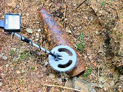
Image courtesy of JP
In the Huertgen Forest, the usage of a metal detector is regulated.
A metal detecting permit and permission is needed.
“Nordrhein-westfälisches Denkmalschutzgesetz”
Explanation about the map references
and the & “Nord de Guerre Grid Sytem”
Please take a look this link.